Maps and plans are historical documents that represent a particular place at a specific point in time. As one of the oldest forms of human communication, maps and plans are diagrammatic representations that allow the user to gain varied insights about a specific place and aspects of its history.
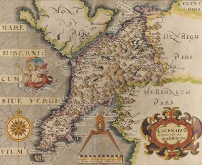
Christopher Saxton’s map of Caernarvon, Wales
Types of maps we hold
Surveying work
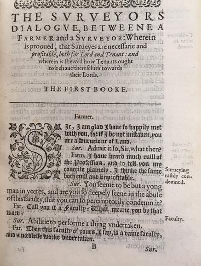
J.Norden, The Surveiors Dialogue (2nd edition, London, 1610)
This image is J.Norden The surveiors dialogue, very profitable for all men to peruse, but especially for all gentlemen, or any other farmar, or hus-bandman ... the true facultie of surveying of all manner of lands and tenements, etc. (2nd edition, London, 1610) Rare books Perkins S509.
In England, the work of Christopher Saxton (c.1542-1606), who surveyed the whole country in the 1570s, marked a new point in topographical description. His survey produced maps of the individual counties of England and Wales, printed for the first time between 1574 and 1579.
Other examples of surveying work documents we hold include:
- Sketch plan, in the hand of Henry John Temple, third Viscount Palmerston, of the plantations in Marks prior to incorporating it into Broadlands Park, 1810, MS 62 Broadlands Archives BR 117/5
- Crumlin, near Dublin: ‘Facsimile of a section of Cromwell’s map of Crumlin, made by virtue of a commission directed by ye Commissioners of ye Com[m]onwealth of England for ye affairs of Ireland, dated ye 31 of October 1653’, MS 69/4/13
- A copy of a letter from Neville Bath to H.Clements, about his maps of the counties of Cork, Kilkenny, Tipperary and Limerick, 24 February 1808, forwarded by Thomas Burgh, Commissioner of the Irish Board of Customs, to Sir Arthur Wellesley, Chief Secretary for Ireland, 12 March 1808, MS 61 Wellington Papers 1/193/46
Atlases
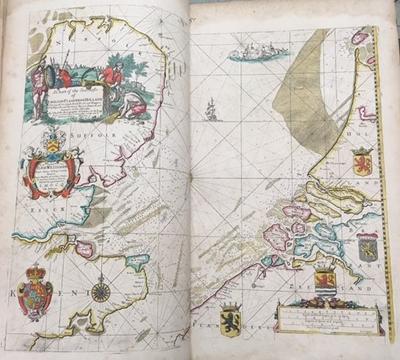
John Seller, Atlas Maritimus, or, the Sea-atlas (London, 1675)
This image is John Seller's Atlas Maritimus, or, the Sea-atlas (London, 1675) Rare Books double folio G 1059. It shows the work of the first Englishman to establish an atlas publishing business, John Seller (1639-1697). He was responsible for forming a celestial atlas and two terrestrial atlases, in addition to Atlas Maritimus (shown in the image).
Other examples of atlases we hold include:
- Abraham Ortelius Il Theatro del Mondo (Brescia, 1598) Rare Books G 1015
- Philip Cluver Introductio in universam geographiam tam veterem, quam novam … (Amsterdam, 1683) Rare Books G 120
- Sébastien de Beaulieu, sieur de Pontault Les Plans et profils des principales villes et lieux considerables du comté d’Alost, ou Flandre imperiale avec la carte generale et les particulieres de chaq[ue] gouvernement... (Paris, c.1690) Rare Books G 6013.F6
Town and Country Maps
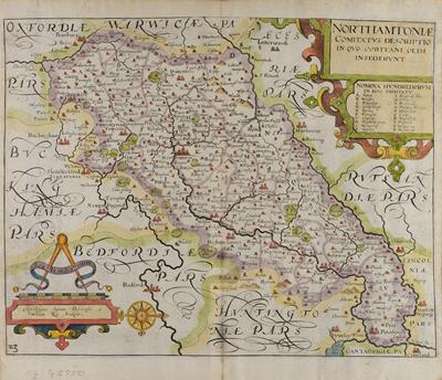
Christopher Saxton’s map of Northamptonshire
This image is Christopher Saxton’s maps of Northamptonshire, engraved by William Kip (c.1637) Rare Books cq G 5750.
Christopher Saxton (c.1542-1606) undertook a government sponsored survey of the whole country during the 1570s, producing single sheet maps of counties, which were also published as an atlas in 1579. The maps show hills and mountains, sandbanks, rivers, towns, villages and bridges but do not provide precise information as to their location or altitude. Smaller maps based on Saxton’s work were later engraved by William Kip and William Hole for editions of Camden’s Britannia.
Other examples of town and county maps we hold include:
- Maps engraved by Pieter van den Keere, from John Speed England, Wales, Scotland and Ireland Described and Abridged … (London, 1627) Rare Books G 5750
- A Plan of Southampton and the Polygon, engraved by P. Mazell (1771) Rare Books Cope SOU 90.5 1771
Military maps
Maps made specifically for military purposes would show battles, lines of attack and defence, fortifications, and enemy positions. They would also be used to display strategy plans in particular campaigns.
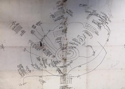
Sketch map MS 61 Wellington Papers 15/7
This sketch map shows Lieutenant Colonel Montresor’s attack on Arrekeery and the surrounding villages in Bullum MS 61 Wellington Papers 15/7.
Examples of other military maps we hold include:
- Map of the battle of Waterloo, taken on the spot after the action of 18 June, 1 August 1815 MS 351/6 A4170/3
- Map of the allied front between Arras and Cambrai taken from The Times, with marks in red ink, within pages of the diary of Revd Michael Adler, Senior Jewish Chaplain to the British Expeditionary Forces, for April 1917: the page opposite the map lists funerals of soldiers killed during the battle of Arras. MS 125 AJ 16/3
Communication
Maps and plans are important in helping to determine the most suitable routes for canals, roads and railways. They can form part of a feasibility survey and facilitate building and maintenance.
Coastal charts
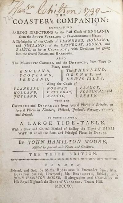
John Hamilton Moore The Coaster’s Companion 3rd ed. (London, 1799)
Printed pilot books developed from the ‛rutters’, the collections of manuscript directions for sailing in coastal waters which were based on personal knowledge. They continued to have a role even after the development of coastal charts of British waters in the early sixteenth century.
Other examples of coastal charts sources we hold include the Greenville Collins Great Britain’s Coasting-Pilot (London, 1781) Rare Books double folio VK 827.
Roads
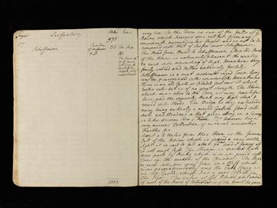
Journal of Henry Temple, second Viscount Palmerston, 1788
This image is of the Journal of Henry Temple, second Viscount Palmerston, describing the roads in Turne (now Turin), Italy 1788 MS 62 Broadlands Archives BR15/14.
Other examples of road sources we hold include:
- Thomas Gardiner A Pocket-guide to the English Traveller: being a Compleat Survey and Admeasurement of all the Principal Roads … in England and Wales. In one hundred copper plates (London, 1719) Rare Books DA 650
- Emanuel Bowen Britannia Depicta or Ogilby Improv’d (London, 1749) Rare Books DA 650
- A map of roads, gentlemen’s seats, etc., twelve miles around Southampton, with the Isle of Wight, 1801 Rare Books Cope cq 90.5 1801
Railways
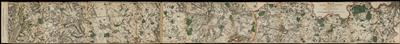
Walker’s London and Southampton Railway, c.1841 Rare Books Cope 43.3
This line map folds into two sections, showing the route of the railway from London to Basingstoke and from Basingstoke to Southampton which was completed in 1840. Guidebooks reveal that the journey between London and Southampton took between two and a half to three hours.
Other examples documents we hold relating to railway maps include:
- Printed extracts of minutes of Proceedings in the House of Lords of Committee, South Eastern, (North Kent) Bill, on 24 July 1846 and 23 March 1847, in respect of the building of a line from Canterbury to Dover, with a map of the proposed North Kent railway MS 61 Wellington Papers 2/235/137-8, 145
- The Visitants’ Guide to Southampton (London, c.1844) Rare Books Cope SOU 03.5 1844. This contains a description of the building of the London to Southampton Railway, between 1835 and 1840.