Research project: Use of multibeam sonar for geological mapping of the seabed
Currently Active:
Yes
Much of the Earth’s surface is covered by water or vegetation. Thus, high quality rock exposures are often limited to narrow tracts of coastal exposure. Recent high resolution sonar imaging of the sea floor has revealed extensive regions of bare rock around our coasts.
Project Overview
Much of the Earth’s surface is covered by water or vegetation. Thus, high quality rock exposures are often limited to narrow tracts of coastal exposure. Recent high resolution sonar imaging of the sea floor has revealed extensive regions of bare rock around our coasts.
This had revealed detailed networks of faults from which it is possible to extract a wide range of geometrical and topological information. Using air photographs of the coastal strip and air-borne Lidar, it is possible to integrate off-shore and on-shore mapping.
We have recently completed mapping of Weymouth Bay that has revealed an amazing new view of the classic geology of the ‘Jurassic Coast’. New techniques allow detailed geological mapping at resolutions that are as good if not better that that achieved on land
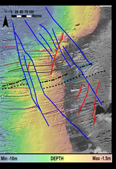
Coastal region in North Devon
Left: A coastal region near Hartland Point in North Devon, where air photographs (grey) have been integrated with multibeam bathymetry (coloured by water depth). It is possible to map the geology from the on-shore to off-shore region. This area forms part of a project to identify and measure networks of faults that controlled deformation of the upper part of the crust.
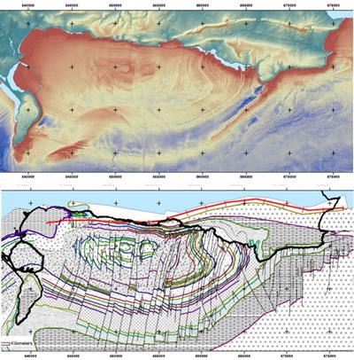
Geological mapping
Left: Geological mapping of the seabed of Weymouth Bay, southern UK, that is bounded to the north by the “Jurassic Coast” World Heritage Site. The upper image shows multibeam bathymetry juxtaposed with on-shore Lidar imagery. These images, together with existing on-shore mapping, air photographs and seismic data, have been used to produce a detailed map of the bay. The new map reveals the detailed stratigraphy of this classical area of geology previously only known from the narrow coastal exposures. The strata are cut by numerous faults, whose location and displacement can be easily measured.