Using mobile phone data to tackle global challenges
Geography and Environment researchers are realising the potential of mobile phone data to address a range of challenges, from the control of infectious diseases to the targeting of disaster relief efforts.
Every time someone sends or receives a call or text from a mobile phone, the communication is routed through the nearest receiving tower, providing an indication of the person’s approximate location. With billions of communications being sent by millions of users through hundreds of towers in each country, this data can provide a detailed and dynamic picture of population movements and densities in a given area.
Professor Andy Tatem and his team at Southampton are at the forefront of research that uses this information in a range of ways – for example, their data modelling techniques are supporting malaria elimination initiatives in Africa and earthquake relief efforts in Nepal.
Malaria elimination
Globally, 3.2 billion people are at risk of malaria, a preventable and treatable mosquito-borne illness. People in the poorest countries are most vulnerable; 90 per cent of deaths occur in sub-Saharan Africa, where most of those affected are under the age of five. Andy’s research is contributing to projects in Africa funded by the Bill and Melinda Gates Foundation, furthering the Foundation’s ultimate goal of eliminating the disease worldwide.
The research uses mobile phone data, alongside information about climate, topography and diagnoses of malaria, to identify malaria ‘hotspots’ and enable the design of targeted prevention plans.
Andy says: "Understanding the movement of people is crucial in eliminating malaria. Attempts to clear the disease from an area can be ruined by highly mobile populations quickly reintroducing the parasite that causes malaria.
"It’s crucial to deploy the right measures in the right places, but in the past figures on human movement patterns in affected regions have been very limited. The rapid global proliferation of mobile phones means we now have an opportunity to study the movement of people, using sample sizes running to millions. This data, combined with disease case-based mapping, can help us plan where and how to intervene."
The research has informed World Health Organization guidelines that are helping 40 countries and sub-regions around the world move towards their target of totally eliminating malaria from their borders.
Forecasting epidemics
Potential future health crises are another focus for our researchers’ work. For example, their sophisticated population modelling techniques have forecast a significant increase in measles cases in Guinea, Liberia and Sierra Leone, caused by interrupted immunisation programmes during the Ebola crisis.
Andy comments: “Our study shows it is crucial to have an aggressive regional vaccination programme in place to help counter the steep drop in immunisation rates. Understanding how measles is likely to spread geographically and where best to concentrate interventions will be vital for an effective response.”
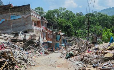
Supporting the Nepal earthquake relief effort
Just a week after the devastating earthquake in Nepal in 2015, Geography and Environment researchers began daily monitoring of phone data; by tracking the displacement of people in affected areas they were able to support the ongoing relief efforts.
The team linked up with the largest mobile phone operator in Nepal to analyse anonymised data from 12 million phones across the country. By comparing information on the movement of these phones after the quake with equivalent pre-quake data, they established trends in population movement.
“This is the first time we have used the method in an ongoing ‘live’ situation,” says Andy. “By watching how the population moves on a daily basis, we have been able to help directly with aid efforts and the rebuilding of infrastructure.”
Collaborative working
Much of Geography and Environment’s research in this field takes place as part of two global collaborations – WorldPop and the Flowminder Foundation – both of which Andy directs.
WorldPop builds detailed and open access population distribution datasets that are used by many governments, UN agencies and international organisations to tackle poverty, plan sustainable urban development and measure disease risks. Flowminder partners with mobile phone network operators to characterise and map vulnerable populations at risk in low and middle-income countries.
Professor Tatem lectures on the undergraduate module Dangerous World and is part of the Population, Health and Wellbeing (PHeW) research group within Geography and Environment. He is also affiliated to Global Environmental Change and Earth Observation (GECEO).
More Geography and Environment research