Key paper on wandering rivers makes journal front cover
Recently published international research findings lead by Professor Paul Carling from Southampton University’s Geography and Environment Earth Surface Dynamics research group are likely to attract considerable attention, not least because a remote sensing image (Fig. 1) associated with the study will feature as the front cover of the October issue of the international journal Geology, published by the Geological Society of America.
The paper was developed from ideas of Professor Carling working closely with former Southampton PhD student Niladri Gupta, now at the Indian Institute of Technology, Guwahati in the Department of Civil Engineering, who developed the necessary data sets, and is entitled: ‘Criticality in the planform behaviour of the Ganges River meanders’.
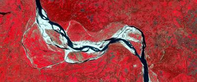
It has often been remarked that the bank erosion along the meanders on the Ganges river is not predictable, and this issue has political importance along the India-Bangladesh border where the Padma reach of the Ganges forms the international border between the two countries. The authors noted that three adjacent Padma meanders had occurred roughly in the same place since the 18th century but bends expanded and then the river cut them off at regular multi-decadal intervals, straightening the channel which then started to meander again. This regular behaviour held out the intriguing possibility that a degree of predictability was possible in terms of when the channels would suddenly straighten. Some rivers simply have a single channel that meanders, whilst others have multiple small channels with many gravel bars – braided rivers. However, some meandering rivers are characterised by active additional minor channels that cut across the meander loops (Fig. 1). The Ganges is one of the latter and these rivers are usually termed ‘wandering rivers’; a style of river that is often considered to be indicative of a system in transition between meandering and braiding in form. The false-colour remote sensing image from February 2015 of the lower part of the Ganges (India-Bangladesh) shows the activation of the cut-off channels as the main channel for water flow while the older channels are being abandoned. The abandoned channels and the active channels depict the oscillating behavior of the sinuosity of the wandering river over space and time.
The causes of wandering river cutoffs and the processes involved can be complicated but in a novel presentation, the authors demonstrate that a simple rule-based approach can be used to show how the meanders are moving closer to the possibility of sudden channel straightening. The role of increasing flow resistance as the river bends tightened coupled with the build-up of the river bed level are paramount controls, with associated predictable and quantitative changes in the radius of a meander bend and its channel width. Using a channel mobility number (M), suggested by Jerolmack and Mohrig in previous work, it is shown that M approaches 1 when the Ganges meanders are due to cutoff. The study demonstrates that the wandering style of a river channel is a sustainable pattern over many decades and it is not necessarily a short-term transitional form positioned between meandering and braided rivers. From a practical perspective, simply calculating M for any given meander can provide some indication of whether the meander is likely to cutoff soon, allowing engineering intervention if appropriate.