New research by Southampton Geography Postgraduate Researcher Andy MacLachlan is developing new methods of defining Urban Heat Island (UHI) effect
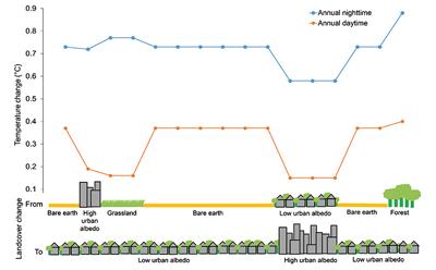
The Urban Heat Island (UHI) effect is considered one of the major challenges of the 21st century. Current analysis fails in policy practicality with singular values depicting differences between urban and natural land. The research by Andy and his colleagues identifies the association between land cover change and temperature, refining development decisions.
The Urban Heat Island (UHI) effect is considered one of the major challenges of the 21st century. Current analysis fails in policy practicality with singular values depicting differences between urban and natural land. The research by Andy and his colleagues identifies the association between land cover change and temperature, refining development decisions.
Urban areas are expected to triple by 2030 due to an expanding global population. Urbanisation of natural land is recognised as the most extreme cumulative effect of land cover change leading to socio-economic and physical consequences such as the Urban Heat Island (UHI) effect that defines increased temperatures over man made surfaces. The UHI effect is often associated with increased mortality, energy consumption and economic expenditure. Consequently the UHI effect is considered one of the major problems posed to humans in the 21st century, with global cities such as London, New York and Tokyo introducing development standards to mitigate UHI exacerbation. Accurate spatial information on land cover-temperature relationships is essential for developing policy on future sustainable city planning to ensure mitigation of urban heat impacts. However, current UHI methodologies fail to detect intra-city variations producing singular values depicting temperature differences between urban and non-urban, preventing targeted policy.
This research presents a multi-sensor satellite earth observation approach in disentangling the complex spatial heterogeneous variations between changes in land cover (Landsat) and land surface temperature (MODIS data). The applied methodology and data permit consistent urban monitoring and identification of the spatial variations between land cover and land surface temperature, enabling refined mitigation of the UHI effect ensuring future sustainable development of our cities.
Links to external websites
- Urban Growth Dynamics in Perth, Western Australia: Using Applied Remote Sensing for Sustainable Future Planning
- Subpixel land-cover classification for improved urban area estimates using Landsat
- Urbanisation-Induced Land Cover Temperature Dynamics for Sustainable Future Urban Heat Island Mitigation
The University cannot accept responsibility for external websites.