Enhanced monitoring of terrestrial vegetation from space
Research led by Professor Jadu Dash, Sir Paul Curran and Dr Booker Ogutu has enhanced the European Space Agency (ESA) and European Commission’s (EC) capability to monitor global vegetation from space. An algorithm was developed and used to underpin ESA’s development of the only global satellite data product estimating terrestrial chlorophyll content in vegetation in near real-time. Distribution of this data has generated major benefits for agricultural and environmental service providers, including timely and targeted responses to poor harvests or plant disease outbreaks. Essential validation data and protocols have also been developed to support quality assurance of satellite-derived vegetation products and ensure their suitability for numerous operational applications, ranging from monitoring biodiversity to drought surveillance.
Overview
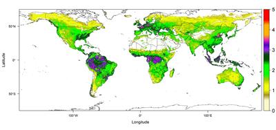
Global distribution of vegetation chlorophyll content.
The research challenge
The condition and productivity of vegetation is controlled by chlorophyll content and concentration within a vegetation canopy. Reliable estimation of vegetation chlorophyll content is vital for forest and agricultural service providers who monitor crop yields, plant health, seasonality, carbon fluxes and carbon sequestration. Accurate and near-real-time estimates of vegetation chlorophyll content can therefore inform timely response to poor harvests or plant disease outbreaks, whilst estimates of global chlorophyll content enable improvements in carbon flux modelling and evaluation of vegetation response to climate change.
Image above right: Showing the global distribution of vegetation chlorophyll content. Areas around rainforest and agriculture activities in Europe and China shows high level of chlorophyll. (Data: Copernicus programme, image process: Harry Morris)
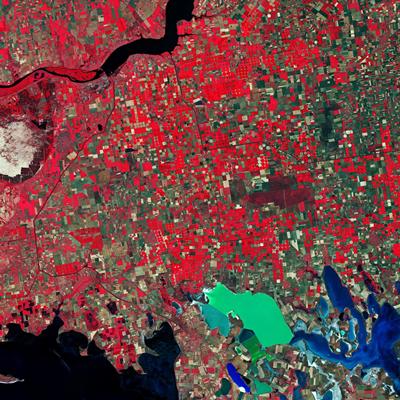
A patchwork of agricultural fields dominate the landscape.
Image right: The image, captured on 26 June 2019, shows a patchwork of agricultural fields dominate the landscape. Ukraine’s main grain crops are winter wheat, spring barley and corn. (contains modified Copernicus Sentinel data (2019), processed by ESA)
What was the impact?
Southampton’s research has made two key contributions to the European Copernicus programme’s capability to monitor global vegetation:
1. The provision of near real-time data on global vegetation chlorophyll content which are routinely distributed to users by ESA
- ESA used Dash’s algorithm to develop a new vegetation data product, the OLCI Terrestrial Chlorophyll Index (OTCI), replacing the MTCI after MERIS ceased operation in 2012. Since the Copernicus Sentinel 3 satellite was launched in October 2016, ESA has used the OTCI as a near real-time global data product on vegetation chlorophyll content; it is currently (July 2021) the only product offering this spatial, temporal and thematic coverage.
- Copernicus programme users have deployed OTCI to monitor and manage terrestrial ecosystems, including estimating forest and crop health.
2. Establishing an operational validation procedure for vegetation monitoring products.
- To ensure the quality of their operational data products meets the expected user requirements, in 2016 the European Commission established a new service called the Ground-Based Observations for Validation (GBOV). Southampton’s research has been key to this, including: specification of validation procedures for three vegetation products – leaf area index (LAI), fraction of vegetation cover (FVC), and fraction of absorbed photosynthetically active radiation (FAPAR); validation of the vegetation component; and design and implementation of one of the largest and most comprehensive ground validation exercises globally.