Unprecedented nature of extreme flooding in North West England revealed
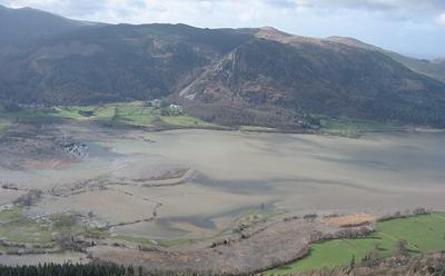
A new study of UK lake sediment records stretching back over several centuries has found that the floods that hit Northern England in 2009 and 2015 (Storm Desmond), were the largest in 600 years – pointing to the impact of climate change on the frequency and magnitude of extreme events.
In a paper published in the journal Earth Surface Processes and Landforms, a team of researchers led by the universities of Southampton and Liverpool, analysed the lake sediment records from these extreme floods and compared them with a 558 year record from the bottom of Bassenthwaite Lake, Cumbria.
A distinct layer of coarser sediment is left in the lake sediment record as material washes in from the surrounding hills and streams providing researchers with a means of recording each flooding event. Sediment layers with the largest grain sizes reflect flooding that was higher energy and more extreme in magnitude.
This is the first time a long term insight into the changing frequency and size of flood events has been produced using lake sediment records for the UK, and it shows how these archives can extend river flows used in conventional flood estimation, which only span relatively short period of 30-50 years.
Professor David Sear, from the University of Southampton’s School of Geography and Environmental Science, who sits on the Defra/EA Flood Risk Management Technical Advisory Group, and co-lead the project, said “This research illustrates the value of using a range of different types of evidence to support our understanding of flooding. What we have been able to do for the first time, is take sedimentary records from lake beds and convert them into the kind of data used by flood risk managers.
“These are the events that cause most damage and cost to society so improving our ability to estimate their chance of occurring is important. In the UK and globally, there are a large number of lakes that our research shows could act as long term flood ‘gauges’, opening up the possibility of new and longer records for different regions of the UK and world. Together they could help us better understand changes in flood hazards.”
Richard Chiverrell, Professor of Physical Geography with the University of Liverpool’s School of Environmental Sciences and lead author of the study, said: “This research study places the recent the extreme flooding events of the last 20 years in a far longer context, providing new insights into the frequency and magnitude of the really large flood events.
“The unprecedented nature of the recent phase of extreme floods accords with statements from the Environment Agency that climate changes and associated impacts on the frequency and magnitude of extreme events are one of the greatest challenges facing our society.
“By establishing long term flood frequency models that use both sediment records and river flow data we hope to be able to improve our ability to quantify flood risk and better support flood risk management in the UK and more widely.”
A new long-term strategy to tackle flooding and coastal change was recently launched by the Environment Agency. With five million people in England are at risk from flooding, and with significant risk to property and infrastructure during floods, the Environment Agency called for a new approach to ensure communities are resilient to the threat of flooding posed by climate change.
The research, which involved the universities of Liverpool, Southampton, Durham and Kings College London, was funded by the UK Natural Environment Research Council Urgency Programme.
Related Staff Member
Professor David Sear BSc, PhD, FRGS, MCIWEM
Professor David Sear is a Professor in Physical Geography within Geography and Environmental Science at the University of Southampton.
Read more