New technique to calculate population in census challenged countries

Researchers from the University of Southampton have developed a new way of estimating population in countries where carrying out a full census is difficult to achieve.
Population and housing censuses are crucial for helping governments plan public health programmes, infrastructure projects and government services, but war, instability and poor resources can all play a part in making them challenging to conduct.
The Democratic Republic of the Congo hasn’t had a census since 1984 and the last national census in Afghanistan was in 1979. Nigeria, the subject of this new study, has had to rely on projections from census data collected in 2006 to help its efforts to eliminate polio and implement yellow fever vaccination campaigns.
Now a team of researchers at WorldPop have developed a way of helping to overcome this problem – to estimate population in hard-to-survey settings by combining data from neighbourhood-scale microcensus surveys (population counts undertaken in small areas) with information from national-scale satellite imagery and digital mapping. They use sophisticated modelling to extrapolate high-resolution national population estimates from the relatively sparse microcensus data.
Findings of the study, funded by the Bill and Melinda Gates Foundation and the UK Foreign, Commonwealth & Development Office as part of the Geo-Referenced Infrastructure and Demographic Data for Development (GRID3) program, are published in the journal PNAS.
Lead author Douglas Leasure of the University of Southampton said: “Population estimates can quickly become inaccurate in localised areas, particularly where migration or displacement has taken place. Some countries are basing decisions about important issues, such as vaccine programmes and social care, on out-of-date data – sometimes well over ten years old.”
The researchers’ estimates of population density for each 100m grid cell across Nigeria were based on recent household surveys from a sample of about 1,100 locations combined with information from satellite images and other geospatial data with national coverage. The gridded approach allows population estimates to be obtained for any geographic area—administrative units, health catchment areas, school districts, etc.—by combining 100m grid cells within the area of interest.
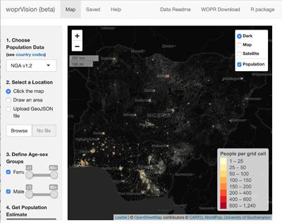
The team has also developed an open data repository called the WorldPop Open Population Repository (WOPR) that provides access to the raw data produced from their bespoke population models for individual countries. They've also created a web application - woprVision - for interacting with the probabilistic population estimates on a map.
"The Nigeria model was the first to go into these platforms, but we are now adding more countries," said Douglas Leasure. "The app allows users to click a point on the map or highlight a specific area to get population estimates with Bayesian estimates of uncertainty, and to get population estimates for specific age and gender groups.
"It is important to note that uncertainty in the data actually has practical uses,” Leasure continued. “For example, if a vaccination campaign has planned for 10,000 doses of vaccine for an area, they can use the web application to identify the probability that the target population in a specific area exceeds that number.
"Even if the most likely population estimate is 10,000 people, the uncertainty may still indicate that there is a relatively high probability that 10,000 doses will not cover the entire target population, in which case the campaign planners can take this into account," he concluded.
Commenting on the research, Director of WorldPop Professor Andy Tatem said: “While there is no substitute for the wealth of information collected in a national census, our technique, at the fraction of the cost, could help many countries unable to conduct a full survey, as well as compliment and support the process of conducting a national census. Accurate, spatially detailed, and up-to-date population figures are a key component for understanding the impacts of events such as conflicts, disasters, or improvements in health care, as well as for planning for potential future population trajectories.”
The paper National population mapping from sparse survey data: A hierarchical Bayesian modeling framework to account for uncertainty is published in the journal PNAS.