Ocean Sensing: anthropological reflections on a field trip to Studland Bay Marine Conservation Zone (MCZ)
By Alejandro Limpo-González[1]
When making the final corrections to this article, state representatives at UN headquarters in New York reached a historic agreement, the High Seas Treaty, a legal agreement "to protect the high sea from overfishing, habitat destruction, ocean acidification, or underwater noise among others growing threats". This regulatory framework faces the ambitious task of putting 30% of the high seas under Marine Protected Areas by 2030.[2] However, in order to enforce the legal frameworks agreed in the text, organisms also need to equip themselves with a coherent spatial representation of the ocean’s life, geography and physical dynamics. Reflecting on MPAs from a visual angle — how the ocean becomes an image, might help to expand our understanding of the ongoing geopolitics in ocean spaces and their transformation into spaces of communication and machine intelligence. My PhD focuses on issues of environmental monitoring and ocean perception. I research how ocean matter intertwines in contemporary media ecologies of environmental observations from a humanities point of view, which entails locating them within an expanded field of social and material relations. This article explores these issues by reflecting on a field trip I conducted with a team of engineers from SMMI to the Marine Conservation Zone in Studland Bay.
I am trained in anthropology and work as a PhD researcher at the University of Southampton. In anthropology, we are accustomed to thinking of technology as a dimension that cuts across the whole of human existence, permeating our experience of the world and of ourselves. Images are particular forms of technology that have evolved and supported human perceptions of the environment at least as far back as cave painting. Considering human existence as intrinsically technological, today it also seems to have become increasingly ecological, oriented to so-called global environments. Spaces like the high seas, the seabed or the water column concentrate today's most pressing geopolitical concerns. These environments become global via their influence on processes like weather and climate, as well as interactive through technical images and machine environments, ‘ecologies of meaning’ that extend beyond human perception and cognition. The most pressing example of these iterations between images and environments is perhaps climate change: a particular state of planetary matter and time highly elusive, when not unfathomable without the satellites, sensor networks and computers that wrap the planet in a computable image. My research builds on these premises to reflect on the expansion of computation as the mode through which Western science and policy understand oceanic matter. I address networked images (images treated as information repositories) as one particular manifestation of the computation of the oceans. This project is being developed as part of Intelligent Oceans, a Leverhulme-trust-funded PhD programme building an interdisciplinary group at the University of Southampton to broaden academic perspectives on society's most pressing oceanic issues.
Having briefly explained what anthropology of technology and the environment is about, I should focus on what anthropologists have on their hands. Ethnography is one of the most popular methods in anthropology. It involves the study of a community's practices and perceptions of its surroundings. In my version of it, I write alongside members of the Ocean Perception Lab (OPLab-IRIS-SMMI). I pay attention to how images are built and used in this lab. I observe parts of the ocean being tracked by humans and robots, on board a research vessel, in laboratory facilities on land, and stacked in online image repositories, screens and models that chase the materiality and meaning of a rapidly changing global environment. I work with oceans embedded in technological and perceptual architectures, skilled know-how and imagination about technology. In this sense, ethnography might be a particular version of ocean science that deals with the ocean as an aesthetic, perceptual, and computable object.
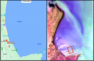
That’s how on 21 September I joined two members of the OpLab and their camera-equipped survey robot Smarty200 on a visual survey of seagrass at the Studland Bay Marine Conservation Zone (MCZ). Studland Bay is a shallow bay located in Dorset, on the South coast of England, where the seabed is dominated by a seagrass species called Zostera marina. Seagrass is known for being a habitat-forming, like corals, that provides shelter for a wide variety of species, reduces current flow and coastal erosion, and cleans the surrounding water. By doing so, it also removes anthropic effects from the atmosphere (i.e. carbon dioxide). That is why marine scientists refer to these plants as “ecosystem engineers.”
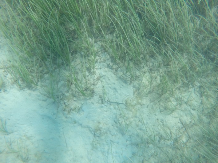
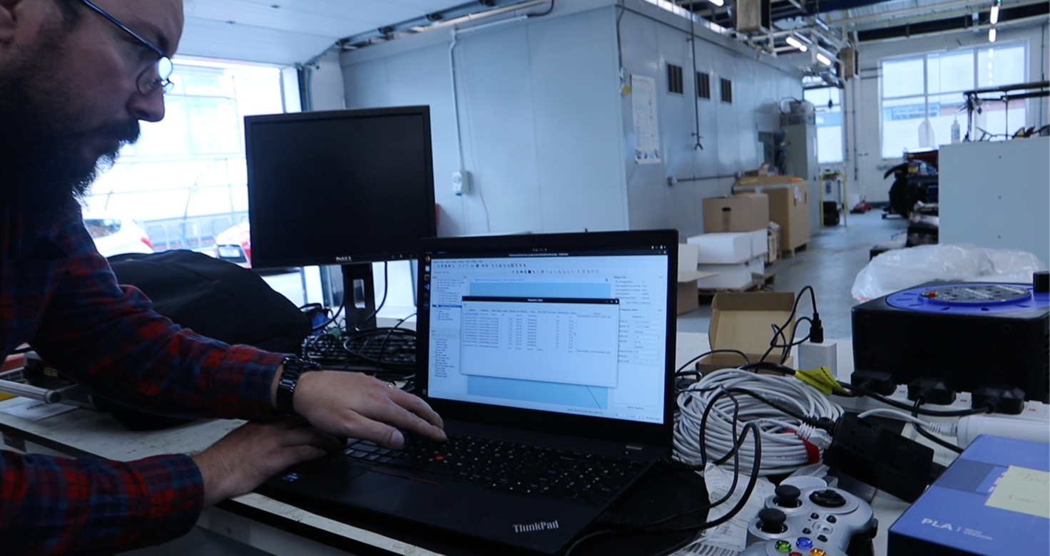
However, seagrasses are also slow-growing ecosystems that require long periods of recolonisation, and this is why their growth has recently become a subject of modelling and projection. That day, the engineers were testing their new robot in pre-designed "imaging missions" to map the distribution of seagrass beds and monitor their recovery from anchor damage, as well as whether the seagrass beds in Studland Bay were advancing or retreating. For my part, I wanted to learn the ins and outs of marine observation in the field. But the journey truly started the day before, on campus, drawing several lines on a screen plotting the sea in the blue uniform background of the two-dimensional environment of the Geographic Information Software QGIS. These lines deliver locations, a path carefully crafted according to some anchor scars made visible on a previous bathymetry survey of the meadows. Bathymetry surveys are image products made from sound pulses where no seagrass can actually be seen but rather inferred from the sound touching the floor.

Smarty200 would autonomously follow the lines drawn on the screen by taking pictures of the seabed. However, GPS signals are not available underwater, so photographs can have a location mismatch of several tens of metres with the real position of the seagrass. Hence, the actual navigation path followed by Smarty200 would later be used to anchor images themselves to locations on a map.
The next day Smarty200 finds itself in the path-crafted environment it has been designed for, while we had entered the blue canvas. For me, conducting ethnography at sea, coupling the signalled environment in which Smarty200 moves and the one we perceive becomes an experiment in orientation. As the chief engineer, Miquel Massot, points to the buoy, the last visual contact with the robot, the antenna attached to it points to the invisible channel filled with location data, speed and altitude, all the signals that - except GPS - embed the photographs being taken by the robot and will allow him to complete a picture of the seagrass. One of the things I learned from the engineers on deck is that orientation at sea is "to know where to look.” Marine imaging confronts us with those technologies that have ‘freed our eyes’ in our daily life, such as GPS signals, bandwidth, and databases of geolocated satellite images. Just a few metres from the coastline, this airy and invisible atmosphere that supports the signal traffic in which our environmental visual culture is embedded falls apart: GPS signal disappears underwater, and the acoustic channels are too slow to share regular images. In addition, wireless connections are only available on the surface and rely on a constellation of low-bandwidth satellites that make images inaccessible, or "heavy" to take out of the environment, forcing us to bring them ashore "by hand". In some ways, this perception of underwater environments as a data-poor and disconnected environments echoes a persistent Western tradition of describing underwater environments through some kind of deficiency and incompleteness, as in Victorian days, when the abiotic theory in place advocated the non-existence of life in the deep ocean.
Underwater, images lose ground, and I am not referring here to the loss of a phenomenological connection to human minds that is the trend in global environment representations, but rather in purely engineering terms, the connection to the global-scale communication infrastructure that turns them into an addressable token of planetary environments. In order to become intelligible, each image frame must contain information elements: navigation data, positions, velocities, depth and altitude. A delicate balance between signals and data points that informs the actual perceptual topology of the visual survey; that means turning the seagrass habitat into a reusable, networkable, and, ultimately, an addressable entity for a computer system. Just in this way, the density, distribution and rates of carbon sequestration abstracted from the advancement or retreat of the seagrass become an index of the capacity of seagrass to "re-engineer" the environmental characteristics of the seabed in Studland Bay. Could we say that it is through these processes that a local environment becomes a global environment, in terms of media culture?
Let’s consider the time between the slow growth of seagrass meadows and the speed at which the 30,000 photographs captured by Smarty200 can be circulated and viewed by scientists. Miquel is bridging this distance by safeguarding the delicate logistics that inform how knowledge reaches us; nailing down signals and images that will allow algorithms to “look” on the scientists' behalf, helping them orient themselves in the seagrass image dataset. Then, shouldn't we also talk about seagrasses from the point of view of their circulation as image products, as they gain or lose ground in environmental visual infrastructures?
Literary critic Katherine Hayles has coined the term "cognitive assemblages" to refer to the collective work of humans, biological organisms and computational media in meaning-making practices. Perhaps this is a good way to think about what is at stake in marine spatial planning and more broadly in the transformation of that space into a visual space. Should we not build on an environmental understanding that rescues these new senses, spaces and images as much as the frictions among them? Coupling with the movement of the ocean perception team (on the boat, in the lab), paying attention to the engineers in Studland Bay, and learning "where to look,” I also learnt that what is visually objectified as ocean matter, abstracted and re-organized in the territory of servers and databases, cannot be separated from the frictions and media operations in the ocean.
[1] https://www.southampton.ac.uk/people/5z6b9b/mr-alejandro-limpo-gonzalez
[2] https://enb.iisd.org/marine-biodiversity-beyond-national-jurisdiction-bbnj-igc5-resumed-summary