Research Group: Geology and Geophysics
The Geology and Geophysics Research Group is among the largest and most active research groups in this field in Europe.
Within the Geology and Geophysics Group, the concentration of marine geology and geophysics expertise, alongside state-of-the-art facilities and technology development enable research in a wide range of societally impactful areas of geoscience for a sustainable future.
Our research foci include:
Our work is underpinned by world-class facilities for ocean bottom seismology, high resolution sea floor and sub-seafloor imagery, controlled source electromagnetic sounding, the analysis of sediment-rock cores and seafloor samples, high level computing and machine learning, and technique development in all areas.
Contact: Professor Lisa McNeill
We have over 20 years of experience of collecting high resolution geophysical data for research projects as diverse as small object detection (including forensic work), wreck based surveys, Quaternary natural and archaeological landscape studies, neotectonics, and large scale sedimentological and structural analysis.
3D Chirp is a surface-towed sub-bottom profiling system capable of imaging the upper tens of metres of the sub-surface on three dimensions with decimetric horizontal and centimetric vertical resolution.
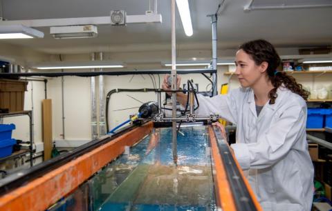
The geology and geophysics research group operates three labs focusing on the study of coastal and shelf sea hydrodynamics and sediment dynamics. Our Coastal Processes and the Coastal Dynamics labs host a range of straight, recirculating and annular flumes equipped with a variety of high-frequency instruments and sensors, and are used for teaching and research into boundary layers, sediment transport and scour, submarine gravity flows and flow/sediment interactions with biota. The Sediment Analysis Lab is equipped with a range of tools used to analyse cohesive and non-cohesive sediment samples, including particle size distribution, grain texture and composition, and bulk sample properties; including a settling column and a Laser Sizer.
The Ocean Bottom Instrumentation Consortium aims to provide the academic and commercial communities with access to multi-sensor, versatile seabed instruments to enable sub-surface geophysical imaging at high vertical and lateral resolution.
The University is equipped to carry out marine controlled source electromagnetic (CSEM) surveys - for both academic and applied research topics.
Our equipment base includes:
The combination of DASI and Vulcan allows sub-bottom electromagnetic profiling to depths of c. 100-200 m beneath the seafloor. This approach can be applied to map resistive gas accumulations or gas hydrate deposits, conductive mineral deposits, and other shallow geological features. We commonly combine this equipment with ocean bottom electromagnetic receivers supplied by OBIC, allowing us also to survey deeper, crustal-scale targets.
GAU-Radioanalytical is an industry and government-agency focussed organisation that offers specialist radioanalytical research and analytical services.
This facility primarily focuses on making high quality sections of a range of materials for teaching and research. Cutting services, vacuum impregnation and staining techniques are also available.
We have one vessel, R.V. Callista, based at NOCS that is available to staff and students of Ocean and Earth Science.
This facility houses state-of-the-art instrumentation as well as a shielded room to support paleomagnetism, rock and mineral magnetism, magnet stratigraphy, and palaeoenvironment related research.
The XRD facility located at NOCS provides a service for the qualitative or quantitative analysis of rock samples to determine bulk mineralogy and/or clay mineralogy.