About this course
Geographical Information Systems (GIS) provides a powerful means to solve complex problems using advanced techniques, primarily through manipulation of geospatial data.
This MSc Geographical Information Systems and Remote Sensing course will equip you with critical theoretical knowledge and the practical skills you’ll need to become an expert in GIS, Geospatial Analysis and Earth Observation.
You’ll explore the fundamentals of GIS and remote sensing, and build your skills to observe, analyse, and make sense of our changing world. You’ll choose from a range of optional modules to gain in-depth understanding of topical and relevant subjects in areas that match your interests and career goals.
Our globally renowned researchers' work feeds directly into the course to shape your learning with the latest thinking to solve real-world problems in areas such as:
- artificial intelligence (AI)
- health geographies
- disaster management
- global carbon cycle
- wildfire monitoring and management
- climate change
You’ll also have opportunities to:
- understand GIS and remote sensing, exploring how geospatial technologies are used to capture data and understand our environment
- develop programming and geospatial data science skills, such as AI or machine learning techniques, for geospatial data analysis
- build transferable skills for research, consultancy, or future PhD studies
- carry out your own research project, with the opportunity to work in partnership with a leading industry or research organisation
- work with world-renowned researchers from WorldPop group, Southampton Geospatial, and the Geodata Institute
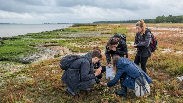
Partnership Projects
Our Partnership Projects initiative gives you the opportunity to complete a Policy, Practice or Industry dissertation in collaboration with an external organisation.
You’ll work on a real brief set by the partner, applying your knowledge to a defined challenge.
Projects may include:
- ecological field studies
- social research into community sustainability initiatives
- identifying new locations for environmental or social charity work
Your research will focus on real-world issues and contribute to practical outcomes.
We regularly review our courses to ensure and improve quality. This course may be revised as a result of this. Any revision will be balanced against the requirement that the student should receive the educational service expected. Find out why, when, and how we might make changes.
Our courses are regulated in England by the Office for Students (OfS).
Course lead
This course is lead by Dr Booker Ogutu. Dr Ogutu is particularly interested in using Earth Observation data to understand how environmental and climate change impact terrestrial ecosystems and influences the global carbon cycle.
Learn more about this subject area
When you start the geography course they tell you ‘you're the people who are going to make a difference, you can be at the forefront of all this'. It's a scary prospect but it’s always made me want to do the best I can.
Amy Bonnie
BSc Geography, MSc GIS and Remote Sensing
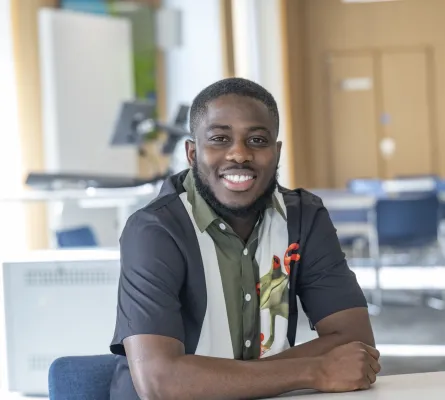
The program provides access to extensive resources for technical and practical learning and research, making it an ideal choice for pursuing higher education in this specialised field.
Bright
MSc Applied GIS and Remote Sensing student
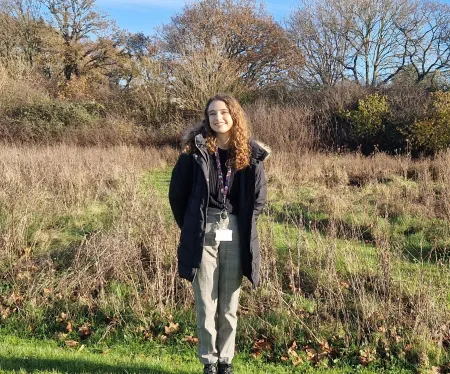
I enjoyed GIS and Remote Sensing during my undergraduate degree. I wanted to develop my skills at a more advanced level at a leading university in the field and develop some related coding skills.
Jessica
MSc Applied GIS and Remote Sensing student
Course location
This course is based at Highfield.
Awarding body
This qualification is awarded by the University of Southampton.
Download the Course Description Document
The Course Description Document details your course overview, your course structure and how your course is taught and assessed.
Entry requirements
You’ll need a 2:2 degree in one of these subjects:
- geography
- physics
- geomatics
- environmental science
- ecology
- biology
- geology
- engineering
Find the equivalent international qualifications for your country.
English language requirements
If English is not your first language, you must show that you can use English to the level we require. Visit our English language pages to find out which qualifications we accept and how you can meet our requirements.
If you are taking the International English Language Testing System (IELTS), you must get at least the following scores:
IELTS score requirements
- overall score
- 6.5
- reading
- 6.5
- writing
- 6.5
- speaking
- 6.5
- listening
- 6.5
If you do not meet the English language requirements through a test or qualification, you may be able to meet them by completing one of our pre-sessional English programmes before you start your course.
Pre-masters
If you don’t meet direct entry requirements, you can apply to complete a Pre-Master's programme through our partnership with OnCampus.
You'll progress to your chosen course after successfully completing the programme. Find out more about Pre-Master's programmes for international students.
Recognition of professional experience
If you don't have the exact entry requirements, but you have significant work experience in this sector we’ll assess your relevant professional experience, your subject knowledge and your aptitude for learning.
Your application will be considered on individual merit and you may be asked to attend an interview.
Got a question?
Please contact us if you're not sure you have the right experience or qualifications to get onto this course.
Email: enquiries@southampton.ac.uk
Tel: +44(0)23 8059 5000
Course structure
Your studies run for a full 12 months, from September to the following September.
For the first 8 months (semesters 1 and 2) you'll focus on the taught part of your course. This consists of modules that everyone on the course takes and modules that we’ll ask you to choose from a list of options.
During semester 2 you’ll begin preparing for your final project.
Exams take place at the end of semesters 1 and 2.
For the last 4 months, over the summer, you’ll work independently on your research project. You’ll have one-to-one meetings with your supervisor during this time to discuss your progress.
Want more detail? See all the modules in the course.
Modules
The modules outlined provide examples of what you can expect to learn on this degree course based on recent academic teaching. As a research-led University, we undertake a continuous review of our course to ensure quality enhancement and to manage our resources. The precise modules available to you in future years may vary depending on staff availability and research interests, new topics of study, timetabling and student demand. Find out why, when and how we might make changes.
For entry in academic year 2026 to 2027
Year 1 modules
You must study the following modules :
Academic and Research Skills
A range of skills are required for those wishing to work in the realm of remote sensing and spatial analysis. This module will help develop the skills base of students with regard to academic skills as well as those of particular value to further research...
Core Skills in GIS
This module is intended to provide foundational GIS skills for various Masters-levels programmes (such as the MSc in Applied GIS and Remote Sensing and various Masters in Environmental Science, Public Health, Global Health etc.). It is intended to introdu...
Fundamentals of Remote Sensing
This module will provide students with an introduction to the fundamental concepts and principles of remote sensing (which broadly involves the use of remote observations, often space-based observations, to make inferences about the state of the Earth's e...
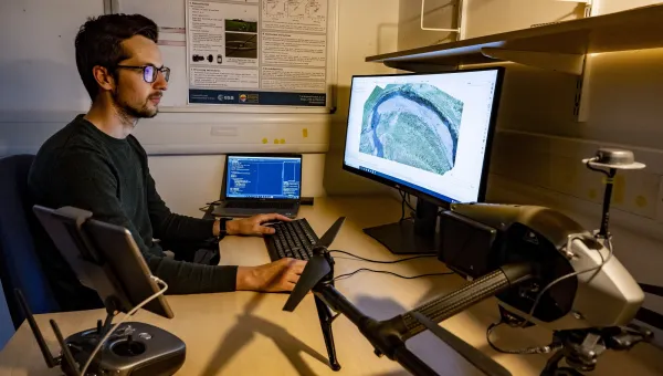
Programming for Geospatial Data Science
This module provides students with the skills to automate geospatial data science workflows using code, specifically code written in the open source programming language Python.
Research Project
Students will conduct a sustained research-based task, culminating in the production of a substantive academic dissertation
You must also choose from the following modules :
Earth Observation for Environment and Society
This module explores the vital role of Earth Observation (EO) in understanding and addressing critical environmental and societal challenges. Students will gain advanced knowledge and practical skills in using EO data to monitor and assess issues such as ...
Active Remote Sensing
This module will introduce the techniques and contemporary methods used in active remote sensing systems, focusing on LIDAR and RADAR systems. The module will cover the fundamental principles of active remote sensing (e.g. the measurement techniques of th...
GIS for Analysis of Health
This module is intended to introduce students who have already studied the principles of geographical information systems (GIS) to the concepts, methods and techniques involved in using GIS for the analysis of health. Academic study of the geography of he...
GIS for Environmental Management and Consultancy
This module is intended to introduce students who have already studied the principles of Geographical Information Systems (GIS) how to utilise GIS tools in environmental management. Environmental applications require specific skills on the part of the GIS...
Machine Learning for Geospatial Data Science
The module provides students with practical skills in applied machine learning while fostering a multidisciplinary perspective that integrates remote sensing, GIS, and data science. It introduces a data-driven mindset and builds a bridge between geography...
Learning and assessment
Learning
You'll learn through a variety of methods, including lectures, seminars and tutorials.
Other learning methods will vary according to your choice of modules but could include:
- guest lectures
- independent study
- group and individual work
- presentations
Assessment
We’ll assess you using a variety of methods. These include:
- exams
- reports
- essays
- group assignments
- in-class tests
- research project
Dissertation
For your final project you’ll research and write a dissertation on a subject of your choice, to be agreed with your supervisor.
The project is an opportunity for you to show your research skills and knowledge of your subject. You’ll have regular meetings with your supervisor to discuss your progress.
You might decide that you want to carry out your research project with a partner organisation.
Previous research projects have included:
- investigating the use of remote sensing to assess recovery after the 2010 Haiti earthquake
- the use of satellite data to detect near-real time deforestation in the Democratic Republic of Congo
- The use of GIS to plan stroke-related healthcare delivery
Academic Support
We'll assign you a personal academic tutor, and you'll have access to a senior tutor.
Careers and employability
The employability and enterprise skills you'll gain from this course are reflected in the Southampton skills model. When you join us you'll be able to use our skills model to track, plan, and benefit your career development and progress.
Download skills overview

Work experience opportunities
Choosing to do work experience is a great way to enhance your employability, build valuable networks, and evidence your potential. Learn about the different work and industry experience options at Southampton.
Careers services and support
We are a top 20 UK university for employability (QS Graduate Employability Rankings 2022). Our Careers, Employability and Student Enterprise team will support you. This support includes:
- work experience schemes
- CV and interview skills and workshops
- networking events
- careers fairs attended by top employers
- a wealth of volunteering opportunities
- study abroad and summer school opportunities
We have a vibrant entrepreneurship culture and our dedicated start-up supporter, Futureworlds, is open to every student.
Your career ideas and graduate job opportunities may change while you're at university. So it is important to take time to regularly reflect on your goals, speak to people in industry and seek advice and up-to-date information from Careers, Employability and Student Enterprise professionals at the University.
Fees, costs and funding
Tuition fees
Fees for a year's study:
- UK students pay £10,400.
- EU and international students pay £31,200.
Deposit
If you're an international student on a full-time course, we'll ask you to pay £2,000 of your tuition fees in advance, as a deposit.
Your offer letter will tell you when this should be paid and provide full terms and conditions.
Find out about exemptions, refunds and how to pay your deposit on our tuition fees for overseas students page.
What your fees pay for
Your tuition fee covers the full cost of tuition and any exams. The fee you pay will remain the same each year from when you start studying this course. This includes if you suspend and return.
Find out how to pay your tuition fees.
Accommodation and living costs, such as travel and food, are not included in your tuition fees. There may also be extra costs for retake and professional exams.
Explore:
10% alumni discount
If you’re a graduate of the University of Southampton, you could be eligible for a 10% discount on your postgraduate tuition fees.
Postgraduate Master’s Loans (UK nationals only)
This can help with course fees and living costs while you study a postgraduate master's course.
If you study part-time, you may not be eligible for this loan. Find out if you're eligible.
Funding your postgraduate studies
A variety of additional funding options may be available to help you pay for your master’s study. Both from the University and other organisations.
Funding for EU and international students
Find out about funding you could get as an international student.
How to apply
- Use the blue 'apply for this course' button on this page to take you to our postgraduate admissions system.
- Create an account which gives you access to your own application portal.
- Search for the course you want to apply for.
- Complete the application form and upload any supporting documents.
- Submit your application.
For further details of our admission process, read our step by step guide to postgraduate taught applications.
Application deadlines
UK students
The deadline to apply for this course is Wednesday 2 September 2026, midday UK time.
We advise applying early as applications may close before the expected deadline if places are filled.
International students
The deadline to apply for this course is Wednesday 19 August 2026, midday UK time.
We advise applying early as applications may close before the expected deadline if places are filled.
Application assessment fee
There is no application assessment fee for postgraduate courses starting in 2026.
Supporting information
When you apply you’ll need to submit a personal statement explaining why you want to take the course.
You’ll need to include information about:
- your knowledge of the subject area
- why you want to study a postgraduate qualification in this course
- how you intend to use your qualification
You'll also need to submit two references, one academic reference and one academic or professional reference.
Please include the required paperwork showing your first degree and your IELTS English language test score (if you are a non-native English speaker) with your application. Without these, your application may be delayed.
What happens after you apply
You'll be able to track your application through our online Applicant Record System.
We will aim to send you a decision 6 weeks after you have submitted your application.
If we offer you a place, you will need to accept the offer within 30 working days. If you do not meet this deadline, we will offer your place to another applicant.
Unfortunately, due to number of applications we receive, we may not be able to give you specific feedback on your application if you are unsuccessful.
Equality and diversity
We treat and select everyone in line with our Inclusion and Respectful Behaviour Policy.
Got a question?
Please contact us if you're not sure you have the right experience or qualifications to get onto this course.
Email: enquiries@southampton.ac.uk
Tel: +44(0)23 8059 5000
Related courses
Geographical Information Systems and Remote Sensing (MSc) is a course in the
Geography and environmental science
subject area.
Here are some other courses within
this subject area:
-
Study
- View all courses
- Taught postgraduate study
- Pre-sessional English courses
-
Subjects
- Acoustical engineering
- Aeronautical and astronautical engineering
- Ageing and gerontology
- Archaeology
- Art, design and fashion
- Audiology
- Biological sciences
- Biomedical and medical engineering
- Business, accounting, finance and marketing
- Chemistry
- Civil engineering
- Computer science and software engineering
- Economics
- Education
- Electrical and electronic engineering
- English
- Film studies
- French
- Geography and environmental science
- History
- Languages and linguistics
- Law
- Maritime engineering
- Mathematical sciences
- Mechanical engineering
- Medicine
- Music
- Nursing, midwifery and healthcare
- Ocean and Earth science
- Philosophy
- Photonics and optoelectronics
- Physics and astronomy
- Politics and international relations
- Psychology
- Social statistics and demography
- Sociology, social policy and criminology
-
PhDs and research degrees
- Create your own research project
-
Find a PhD project
- A missing link between continental shelves and the deep sea: Have we underestimated the importance of land-detached canyons?
- A study of rolling contact fatigue in electric vehicles (EVs)
- Acoustic monitoring of forest exploitation to establish community perspectives of sustainable hunting
- Acoustic sensing and characterisation of soil organic matter
- Advancing intersectional geographies of diaspora-led development in times of multiple crises
- Aero engine fan wake turbulence – Simulation and wind tunnel experiments
- Against Climate Change (DACC): improving the estimates of forest fire smoke emissions
- All-in-one Mars in-situ resource utilisation (ISRU) system and life-supporting using non-thermal plasma
- An electromagnetic study of the continent-ocean transition southwest of the UK
- An investigation of the relationship between health, home and law in the context of poor and precarious housing, and complex and advanced illness
- Antibiotic resistance genes in chalk streams
- Being autistic in care: Understanding differences in care experiences including breakdowns in placements for autistic and non-autistic children
- Biogeochemical cycling in the critical coastal zone: Developing novel methods to make reliable measurements of geochemical fluxes in permeable sediments
- Bloom and bust: seasonal cycles of phytoplankton and carbon flux
- British Black Lives Matter: The emergence of a modern civil rights movement
- Building physics for low carbon comfort using artificial intelligence
- Business studies and management: accounting
- Business studies and management: banking and finance
- Business studies and management: decision analytics and risk
- Business studies and management: digital and data driven marketing
- Business studies and management: human resources (HR) management and organisational behaviour
- Business studies and management: strategy, innovation and entrepreneurship
- Carbon storage in reactive rock systems: determining the coupling of geo-chemo-mechanical processes in reactive transport
- Cascading hazards from the largest volcanic eruption in over a century: What happened when Hunga Tonga-Hunga Ha’apai erupted in January 2022?
- Characterisation of cast austenitic stainless steels using ultrasonic backscatter and artificial intelligence
- Climate Change effects on the developmental physiology of the small-spotted catshark
- Climate at the time of the Human settlement of the Eastern Pacific
- Collaborative privacy in data marketplaces
- Compatibility of climate and biodiversity targets under future land use change
- Cost of living in modern and fossil animals
- Creative clusters in rural, coastal and post-industrial towns
- Deep oceanic convection: the outsized role of small-scale processes
- Defect categories and their realisation in supersymmetric gauge theory
- Defining the Marine Fisheries-Energy-Environment Nexus: Learning from shocks to enhance natural resource resilience
- Design and fabrication of next generation optical fibres
- Developing a practical application of unmanned aerial vehicle technologies for conservation research and monitoring of endangered wildlife
- Development and evolution of animal biomineral skeletons
- Development of all-in-one in-situ resource utilisation system for crewed Mars exploration missions
- Ecological role of offshore artificial structures
- Effect of embankment and subgrade weathering on railway track performance
- Efficient ‘whole-life’ anchoring systems for offshore floating renewables
- Electrochemical sensing of the sea surface microlayer
- Engagement with nature among children from minority ethnic backgrounds
- Enhancing UAV manoeuvres and control using distributed sensor arrays
- Ensuring the Safety and Security of Autonomous Cyber-Physical Systems
- Environmental and genetic determinants of Brassica crop damage by the agricultural pest Diamondback moth
- Estimating marine mammal abundance and distribution from passive acoustic and biotelemetry data
- Evolution of symbiosis in a warmer world
- Examining evolutionary loss of calcification in coccolithophores
- Explainable AI (XAI) for health
- Explaining process, pattern and dynamics of marine predator hotspots in the Southern Ocean
- Exploring dynamics of natural capital in coastal barrier systems
- Exploring the mechanisms of microplastics incorporation and their influence on the functioning of coral holobionts
- Exploring the potential electrical activity of gut for healthcare and wellbeing
- Exploring the trans-local nature of cultural scene
- Facilitating forest restoration sustainability of tropical swidden agriculture
- Faulting, fluids and geohazards within subduction zone forearcs
- Faulting, magmatism and fluid flow during volcanic rifting in East Africa
- Fingerprinting environmental releases from nuclear facilities
- Flexible hybrid thermoelectric materials for wearable energy harvesting
- Floating hydrokinetic power converter
- Glacial sedimentology associated subglacial hydrology
- Green and sustainable Internet of Things
- How do antimicrobial peptides alter T cell cytokine production?
- How do calcifying marine organisms grow? Determining the role of non-classical precipitation processes in biogenic marine calcite formation
- How do neutrophils alter T cell metabolism?
- How well can we predict future changes in biodiversity using machine learning?
- Hydrant dynamics for acoustic leak detection in water pipes
- If ‘Black Lives Matter’, do ‘Asian Lives Matter’ too? Impact trajectories of organisation activism on wellbeing of ethnic minority communities
- Illuminating luciferin bioluminescence in dinoflagellates
- Imaging quantum materials with an XFEL
- Impact of neuromodulating drugs on gut microbiome homeostasis
- Impact of pharmaceuticals in the marine environment in a changing world
- Improving subsea navigation using environment observations for long term autonomy
- Information theoretic methods for sensor management
- Installation effect on the noise of small high speed fans
- Integrated earth observation mapping change land sea
- Interconnections of past greenhouse climates
- Investigating IgG cell depletion mechanisms
- Is ocean mixing upside down? How mixing processes drive upwelling in a deep-ocean basin
- Landing gear aerodynamics and aeroacoustics
- Lightweight gas storage: real-world strategies for the hydrogen economy
- Machine learning for multi-robot perception
- Machine learning for multi-robot perception
- Marine ecosystem responses to past climate change and its oceanographic impacts
- Mechanical effects in the surf zone - in situ electrochemical sensing
- Microfluidic cell isolation systems for sepsis
- Migrant entrepreneurship, gender and generation: context and family dynamics in small town Britain
- Miniaturisation in fishes: evolutionary and ecological perspectives
- Modelling high-power fibre laser and amplifier stability
- Modelling soil dewatering and recharge for cost-effective and climate resilient infrastructure
- Modelling the evolution of adaptive responses to climate change across spatial landscapes
- Nanomaterials sensors for biomedicine and/or the environment
- New high-resolution observations of ocean surface current and winds from innovative airborne and satellite measurements
- New perspectives on ocean photosynthesis
- Novel methods of detecting carbon cycling pathways in lakes and their impact on ecosystem change
- Novel technologies for cyber-physical security
- Novel transparent conducting films with unusual optoelectronic properties
- Novel wavelength fibre lasers for industrial applications
- Ocean circulation and the Southern Ocean carbon sink
- Ocean influence on recent climate extremes
- Ocean methane sensing using novel surface plasmon resonance technology
- Ocean physics and ecology: can robots disentangle the mix?
- Ocean-based Carbon Dioxide Removal: Assessing the utility of coastal enhanced weathering
- Offshore renewable energy (ORE) foundations on rock seabeds: advancing design through analogue testing and modelling
- Optical fibre sensing for acoustic leak detection in buried pipelines
- Optimal energy transfer in nonlinear systems
- Optimal energy transfer in nonlinear systems
- Optimizing machine learning for embedded systems
- Oxidation of fossil organic matter as a source of atmospheric CO2
- Partnership dissolution and re-formation in later life among individuals from minority ethnic communities in the UK
- Personalized multimodal human-robot interactions
- Preventing disease by enhancing the cleaning power of domestic water taps using sound
- Quantifying riparian vegetation dynamics and flow interactions for Nature Based Solutions using novel environmental sensing techniques
- Quantifying the response and sensitivity of tropical forest carbon sinks to various drivers
- Quantifying variability in phytoplankton electron requirements for carbon fixation
- Resilient and sustainable steel-framed building structures
- Resolving Antarctic meltwater events in Southern Ocean marine sediments and exploring their significance using climate models
- Robust acoustic leak detection in water pipes using contact sound guides
- Silicon synapses for artificial intelligence hardware
- Smart photon delivery via reconfigurable optical fibres
- The Gulf Stream control of the North Atlantic carbon sink
- The Mayflower Studentship: a prestigious fully funded PhD studentship in bioscience
- The calming effect of group living in social fishes
- The duration of ridge flank hydrothermal exchange and its role in global biogeochemical cycles
- The evolution of symmetry in echinoderms
- The impact of early life stress on neuronal enhancer function
- The oceanic fingerprints on changing monsoons over South and Southeast Asia
- The role of iron in nitrogen fixation and photosynthesis in changing polar oceans
- The role of singlet oxygen signaling in plant responses to heat and drought stress
- Time variability on turbulent mixing of heat around melting ice in the West Antarctic
- Triggers and Feedbacks of Climate Tipping Points
- Uncovering the drivers of non-alcoholic fatty liver disease progression using patient derived organoids
- Understanding recent land-use change in Snowdonia to plan a sustainable future for uplands: integrating palaeoecology and conservation practice
- Understanding the role of cell motility in resource acquisition by marine phytoplankton
- Understanding the structure and engagement of personal networks that support older people with complex care needs in marginalised communities and their ability to adapt to increasingly ‘digitalised’ health and social care
- Unpicking the Anthropocene in the Hawaiian Archipelago
- Unraveling oceanic multi-element cycles using single cell ionomics
- Unravelling southwest Indian Ocean biological productivity and physics: a machine learning approach
- Using acoustics to monitor how small cracks develop into bursts in pipelines
- Using machine learning to improve predictions of ocean carbon storage by marine life
- Vulnerability of low-lying coastal transportation networks to natural hazards
- X-ray imaging and property characterisation of porous materials
- Funding your research degree
- How to apply for a PhD or research degree
- How to make a PhD enquiry
- Support while studying your PhD or research degree
- Exchanges and studying abroad
- Undergraduate study
-
Tuition fees, funding and scholarships
- Fee status
- Scholarships
- Undergraduate funding options
-
Postgraduate funding options
-
Postgraduate scholarships
- Black Futures Postgraduate Research Scholarships (Environmental and Life Sciences)
- Black Futures scholarship
- China Excellence Scholarship
- GREAT Scholarships 2025 – Egypt
- GREAT Scholarships 2025 – France
- GREAT Scholarships 2025 – Ghana
- GREAT Scholarships 2027 – USA
- Horizon Europe fee waiver
- India Excellence Scholarship
- Nigeria Excellence Scholarship
- Nursing Global Impact Scholarship (Child Nursing and Mental Health Nursing)
- Postgraduate Taught Diversity Scholarship (Environmental and Life Sciences)
- Social Impact Scholarships
- Southampton Business School (MSc) Dean Scholarship (UK)
- Southampton Faculty of Medicine PGT Talent Scholarship
- Southampton History Patricia Mather and Helen Patterson Scholarship
- Southampton MA Holocaust scholarships
- Southampton Philosophy David Humphris-Norman Scholarship
- Southampton Philosophy MA Scholarship
- Southampton Photonics Impact Scholarship
- Thailand Excellence Scholarship
- The National Institute for Health and care Research South Central INSIGHT Programme
- The South Coast Doctoral Training Partnership Social Science PhD Studentships
- Vietnam Excellence Scholarship
- Winchester School of Art Inclusive Futures Scholarship
- Spärck AI Scholarship
-
Postgraduate scholarships
-
International funding options
-
Scholarships for international students
- Engineering Global Talent Scholarship
- Higher Education Scholarships for Palestinians - HESPAL
- Medical Technology, Innovation and Design Master’s Scholarship
- Merit scholarships for international undergraduates
- Presidential bursaries
- Vice-Chancellor’s Global Achievers Award
- Winchester School of Art Postgraduate Global Talent Scholarship
- Becas Chile Scholarship
- Chevening Scholarships
- China Scholarship Council Scholarships
- COLFUTURO Scholarships
- Commonwealth Distance Learning Scholarships
- Commonwealth Master's Scholarships
- Commonwealth PhD Scholarships
- Commonwealth PhD Scholarships for high income countries
- Commonwealth Shared Scholarships
- Excellence Scholarship
- FIDERH Scholarships
- Southampton Education Civic Scholarship
- Fulbright Awards
- Southampton Ageing and Gerontology Talent Scholarship
- Southampton Teachers' Postgraduate Scholarship
- FUNED Scholarships
- Great Scholarships 2025 – Mexico
- Great Scholarships 2026 – Nigeria
- Marshall Scholarship
- Saïd Foundation Scholarships
- Southampton Canadian Prestige Scholarship for Law
- Xiamen University PhD Scholarships
- GREAT scholarships 2026 – Indonesia
-
Scholarships for international students
- External funding opportunities
- Short courses
- Lunchtime evening and weekend courses
- Clearing
- Summer schools
- Get a prospectus
- Student life
-
Research
- Our impact
- Research projects
- Research areas
- Research facilities
- Collaborate with us
-
Institutes, centres and groups
- Active Living
- Advanced Fibre Applications
- Advanced Laser Laboratory
- Advanced Project Management Research Centre
- Antibody and Vaccine Group
- Astronomy Group
- Autism Community Research Network @ Southampton (ACoRNS)
- Bioarchaeology and Osteoarchaeology at Southampton (BOS)
- Bladder and Bowel Management
- Cell and Developmental Biology
- Centre for Defence and Security Research
- Centre for Developmental Origins of Health and Disease
- Centre for Digital Finance
- Centre for Eastern European and Eurasian Studies (CEEES)
- Centre for Empirical Research in Finance and Banking (CERFIB)
- Centre for Geometry, Topology, and Applications
- Centre for Global Health and Policy (GHaP)
- Centre for Green Maritime Innovation (cGMI)
- Centre for Health Technologies
- Centre for Healthcare Analytics
- Centre for Human Development, Stem Cells and Regeneration
- Centre for Imperial and Postcolonial Studies
- Centre for Inclusive and Sustainable Entrepreneurship and Innovation (CISEI)
- Centre for International Film Research (CIFR)
- Centre for International Law and Globalisation
- Centre for Internet of Things and Pervasive Systems
- Centre for Justice Studies
- Centre for Linguistics, Language Education and Acquisition Research
- Centre for Machine Intelligence
- Centre for Maritime Archaeology
- Centre for Medieval and Renaissance Culture (CMRC)
- Centre for Political Ethnography (CPE)
- Centre for Research in Accounting, Accountability and Governance
- Centre for Research on Work and Organisations
- Centre for Resilient Socio-Technical Systems
- Centre for Transnational Studies
- Child and Adolescent Research Group
- Clinical Ethics, Law and Society (CELS)
- Clinical Legal Education
- Computational Nonlinear Optics
- Cyber Security Academy
- Digital Oceans
- EPSRC and MOD Centre for Doctoral Training in Complex Integrated Systems for Defence and Security
- Economic Theory and Experimental Economics
- Economy, Society and Governance
- Electrical Power Engineering
- Environmental Hydraulics
- Gas Photonics in Hollow Core Fibres
- Geochemistry
- Global Health (Demography)
- Global Health Community of Practice
- Gravity group
- High Power Fibre Lasers
- Hollow Core Fibre
- Human Genetics and Genomic Medicine
- Infection
- Infrastructure Group
- Institute of Developmental Sciences
- Institute of Maritime Law (IML)
- Integrated Photonic Devices
- Interdisciplinary Musculoskeletal Health
- International Centre for Ecohydraulics Research (ICER)
- Language Assessment and Testing Unit (LATU)
- Laser-Direct-Write (LDW) Technologies for Biomedical Applications
- Law and Technology Centre
- Long Term Conditions
- Magnetic Resonance
- Mathematical Modelling
- Medicines Management
- Molecular and Precision Biosciences
- Multiwavelength Accretion and Astronomical Transients
- National Biofilms Innovation Centre (NBIC)
- National Centre for Research Methods
- National Infrastructure Laboratory
- Nature-Based Ocean Solutions
- Nonlinear Semiconductor Photonics
- Ocean Perception Group
- Operational Research
- Optical Engineering and Quantum Photonics Group
- Paediatrics and Child Health - Clinical and Experimental Sciences
- People, Property, Community
- Photonic Systems, Circuits and Sensors Group
- Physical Optics
- Primary Care Research Centre
- Quantum, Light and Matter Group
- Silica Fibre Fabrication
- Silicon Photonics
- Skin Sensing Research Group
- Southampton Ethics Centre
- Southampton Health Technology Assessments Centre (SHTAC)
- Southampton High Energy Physics group
- Southampton Imaging
- Southampton Theory Astrophysics and Gravity (STAG) Research Centre
- Stefan Cross Centre for Women, Equality and Law
- String theory and holography
- The India Centre for Inclusive Growth and Sustainable Development
- The Parkes Institute
- Tony Davies High Voltage Laboratory
- Ultrafast X-ray Group
- Vision Science
- WSA Exchange
- Work Futures Research Centre (WFRC)
- Support for researchers
- Faculties, schools and departments
- Interdisciplinary research
- Find people and expertise
- Research Search | Research projects
- Research jobs
- Business
- Global
- About
- Visit
- Alumni
- Departments
- News
- Events
- Contact
b
MSc
Biodiversity and Conservation
e